


WHITEFACE & ESTHER
via the ASRC
Whiteface and Esther Mountains stand alone as two of the most unique High Peaks in the Adirondacks. Whiteface, famous for its history, ski slopes, and summit road, is one of only two High Peaks with an alpine zone, offering unparalleled 360-degree views. Esther, its rugged and lesser-known sibling, is one of the few peaks named after a person, with its legend making it one of the more fascinating 46ers. Together, they provide a fun, moderate day hike, with clear trails, a steep but rewarding climb, and the ability to celebrate at the top with friends who can drive up to meet you.

What to know
Start:
Atmospheric Science
Research Center (ASRC)
Elevation Gain:
3,700 feet
Summit Elevations:
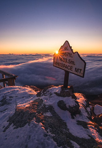
Whiteface Mountain – 4,867 feet
Esther Mountain – 4,240 feet
Trail Length:
9.8 miles out-and-back
Difficulty:
4 out of 7 Moderate
Average Hiking Time:
7–9 hours
View Type:
Whiteface has one of the best 360-degree views in the Adirondacks.
Esther has minimal views, mostly through trees.
Dog Friendliness:
Good hike for dogs, but must be on a leash.
Trail Surface:
Well-worn trail with a mix of rocky, muddy, and gravel sections.
Water Availability:
No natural water sources on the trail—bring all your water.
Maximum Grade:
1.1 miles / 1,300 feet – Steepest section at the start up Marble Mountain.
Sunrise or Sunset:
Whiteface is incredible for both.
Special Considerations:
A great 46er finisher hike since friends and family can drive to the summit.
Expect large crowds on Whiteface in summer, especially near the top.
Intro
Whiteface Mountain has one of the richest histories of any Adirondack High Peak. French explorer Jacques Cartier possibly spotted it from Montreal in 1535. Early settlers in the 1790s believed it to be the tallest peak in the region, and its distinctive, snow-covered face likely contributed to its name. Ebenezer Emmons made the first officially recorded ascent in 1836. The Whiteface Veterans Memorial Highway, built in the 1930s, remains the only paved road to an Adirondack summit, cementing Whiteface’s legacy as a tourist and recreational hub.
Esther Mountain, on the other hand, holds one of the most unique naming stories in the High Peaks. Legend has it that 15-year-old Esther McComb accidentally climbed it in the 1800s while trying to summit Whiteface. Though this story has never been historically verified, it was popularized in the 1920s and 1930s, leading to a plaque being placed at the summit in her honor. Today, Esther remains one of the few High Peaks named after a person.
The Hike

Whiteface Mountain offers four different ascent routes, but when combining Whiteface and Esther, the two most popular approaches are from ASRC (Atmospheric Sciences Research Center) and the Reservoir. For this guide, we will take the quickest and most traveled route, beginning at the ASRC. After locating the correct parking area, as detailed in the trailhead section, you will find an unmarked rocky path leading directly into the woods. This initial section is only 0.1 miles long and quickly brings you to a gravel road. There are no signs marking the beginning of this trail, so be vigilant.
Upon reaching the gravel road, turn left and walk a short distance to reach the base of Marble Mountain. You’ll recognize the start of the trail by signage on the left and an electrical box on the right. The initial climb up Marble Mountain is steep and unrelenting, gaining 800 vertical feet over 0.8 miles. The terrain consists of loose rock and packed dirt, so be sure to pace yourself to conserve energy for the remainder of the hike. As you near the top of Marble Mountain, the trail begins to thin out and the incline becomes more moderate. A small viewpoint on the left provides a decent look back toward Wilmington, while the main trail continues to the right.
Shortly after passing this section, you will arrive at an intersection marked by a sign pointing left toward the Reservoir. Turn right to continue toward Whiteface and Esther. The next stretch covers 1.2 miles with a 1,200-foot climb, making it a steady ascent. The trail is mostly straightforward and well-defined, but you will encounter muddy and rocky patches. The final stretch of this section levels out, leading to a brief flat area before the turnoff to Esther Mountain. This intersection is marked by a large rock cairn, along with a wooden Esther Mountain sign, which states: “Path not maintained or marked.” The spur trail to Esther is a 1-mile out-and-back, and it is the most rugged and challenging section of the entire hike.
To reach Esther Mountain, take the right turn at the intersection, following the narrow and unmaintained herd path. The trail immediately climbs 100 feet to the summit of Lookout Mountain, where a small open ledge on the right offers a limited view of Whiteface Mountain. After cresting the top, the trail descends 100 feet into the col between Lookout and Esther, where you will navigate rocky scrambles and dense forest. At the lowest point, wooden planks cross over wet and boggy terrain, but expect long muddy stretches beyond this section. The trail remains rough and wet as you climb toward Esther’s summit. Near the top, you’ll emerge onto a scenic ledge with a fantastic view of Whiteface, just before reaching the true summit, which is marked by the Esther Macomb plaque. The view from the summit itself is limited, but the nearby ledge provides a stunning perspective of Whiteface and the High Peaks beyond. Once you've taken in the views, retracing your steps back to the Esther intersection is the only way to continue your journey toward Whiteface.


Back at the Esther junction, turn right to continue the 1.5-mile climb to Whiteface’s summit. The first 0.7 miles is a relatively easy and gradual 100-foot incline, before briefly crossing one of Whiteface Mountain’s ski trails. After this, the trail steepens sharply, climbing 0.25 miles to the Memorial Highway. This is marked by a beautiful stone retaining wall on the right, which serves as a clear indicator that you’ve reached the road.
Crossing next to the Whiteface Memorial Highway, the trail resumes, leading you up into a dense, wind-stunted pine forest. The final 0.5-mile stretch is the most exposed and dramatic part of the hike, gradually ascending above the treeline as the terrain transitions to open rock and alpine vegetation. This section is marked by yellow blazes painted on rocks—it is essential to stay on the designated trail to protect the fragile alpine ecosystem. The weather can be unpredictable here, ranging from warm and sunny to harsh winds and freezing temperatures within minutes.
As you approach the summit, you will see the weather observatory station ahead of you. The trail leads to the left side of the station, passing a small service shack, before bringing you up to the final rocky outcrop where the Whiteface Mountain summit sign awaits. Congratulations—you've reached the summit of Whiteface!
If you visit during summer daylight hours, expect to see crowds, as Whiteface is one of the few High Peaks accessible by car via the Memorial Highway. The summit area features a wooden deck surrounding the observatory, offering some of the best views in the Adirondacks, stretching from Lake Champlain to the Green Mountains of Vermont, the High Peaks, and even Montreal on a clear day. You can explore inside the weather observatory, which has interactive exhibits and historical displays.

To descend, you have two options. You can either return the same way you came via the hiking trail, or, if you wish to explore more, you can follow the stone stairs down to the castle—a large stone building that houses a café, gift shop, and viewing platform. From here, you can connect back to the Memorial Highway and pick up the hiking trail again. Regardless of which descent route you take, you will ultimately retrace your steps back to ASRC to complete the hike.

Trail Summary
-
0.0 – Start at ASRC trailhead, following unmarked rocky path.
-
0.1 – Turn left onto gravel road.
-
0.2 – Begin steep climb up Marble Mountain.
-
1.0 – Summit Marble Mountain, turn right at next intersection.
-
2.4 – Reach Esther junction, turn right.
-
3.4 – Summit Esther Mountain, turn around.
-
4.4 – Return to Esther junction, turn right toward Whiteface.
-
4.9 – Cross ski trail.
-
5.2 – Cross toll road, stay right on hiking trail.
-
5.6 – Summit Whiteface Mountain, turn around.
-
9.8 – Arrive back at ASRC trailhead.

ALTERNATE APPROACHES
Reservoir Trail – 12.0 miles, 4,400 feet
This trail follows nearly the same route as the ASRC approach but begins at a lower elevation, adding 700 feet of climbing and two additional miles. The trailhead is located about a mile south of the ASRC along NY 431, where you’ll find signage marking the Wilmington Trail. The hike begins with a 0.1-mile approach to the first trail sign, where you’ll continue straight. After another 0.2 miles, you’ll pass a second sign, again staying straight and following the Wilmington Trail toward Marble Mountain. The next section climbs steadily for a full mile before reaching a junction with a sign pointing right to Marble Mountain. This final 0.8-mile climb gains approximately 1,000 feet, leading you to the summit of Marble Mountain. From here, the trail merges with the ASRC route described in the main hike, following the same path to the summit of Whiteface.
Connery Pond/Whiteface Landing – 13.5 miles, 3,600 feet
This approach, coming from the southwest near Lake Placid, is significantly less traveled and is generally recommended only if Whiteface Mountain is your sole objective. While it is a viable thru-hike option, it is also the most rugged and challenging of all the routes. If combined with Esther, the total mileage increases to around 11.8 miles with 3,700 feet of elevation gain. The trail begins at the Connery Pond Trailhead, where a small parking area accommodates about six vehicles. The initial 2.5 miles offer a pleasant, flat walk through the forest, leading to Whiteface Landing. Here, turn right and follow the signs to Whiteface Mountain. From this point, the summit is 3.5 miles away. The first 1.1 miles lead to a lean-to, marking the base of the primary ascent. The final 2.3 miles climb steeply, gaining 2,700 feet in elevation as you approach the summit.