

SEYMOUR MOUNTAIN
via Coreys Road
Seymour Mountain stands as an isolated challenge in the Seward Range, often hiked separately from its neighboring peaks. While some ambitious hikers attempt to include it in a single-day traverse of the Seward Range, it is commonly tackled as a standalone hike due to its demanding terrain and long approach. This mountain is rugged, heavily eroded, and requires patience, as the final ascent is notoriously steep and slabby. Unlike the primary Seward Range peaks, Seymour is not part of the same ridgeline and sits to the east, separated by deep wilderness.

What to know
Start:
Seward Trailhead
Blueberry Trail
Elevation Gain:
2,800 feet
Summit Elevations:
Seymour Mountain 4,120 feet
Trail Length:
14.6 miles round trip
Difficulty:
4 out of 7 - Moderately Difficult
Average Hiking Time:
8–10 hours
View Type:
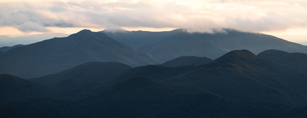
Seymour has excellent views from the ledge before its summit.
Dog Friendliness:
Not the best hike for dogs, but fine if your dog is used to this kind of outing.
Trail Surface:
This trail in is nice,but far less traveled than other ranges; very rugged with tons of rocks, roots, and mud
Water Availability:
Water is scarce. Flowing water can be found at the bottom in various streams.
Maximum Grade:
1,030 feet in 0.45 miles (final ascent of Seymour)
Sunrise or Sunset:
Not ideal for either.
Special Considerations:
Gore-Tex shoes and gaiters are highly recommended.
Intro
Seymour Mountain's first recorded ascent remains a subject of debate. Some sources credit Arnold Guyot and Ernest Sandoz in 1863, while others attribute the first ascent to Verplanck Colvin and his survey team in 1872. Initially called Ragged Mountain due to its rugged, slab-filled terrain, the peak was later renamed Seymour in honor of Horatio Seymour, a former New York governor and influential figure in the conservation movement. Seymour remains one of the more rugged High Peaks, with a trail that has changed over time due to severe erosion and regrowth. The original route followed a thin slide on the north side, but as vegetation overtook the slide, a newer and steeper herd path formed just west of it. Today, Seymour’s trail is considered one of the most eroded and muddy routes in the Adirondacks, with numerous alternative paths developing around the worst sections.

The Hike

At mile 4.8, you’ll reach the Blueberry Lean-to, a possible resting point for backpackers. A short distance later, at mile 5.0, the trail connects with the Ward Brook Truck Trail, a wider and well-traveled path that leads deeper into the range. As you progress, you’ll pass the turn for Seward Mountain at mile 5.2, followed by the Ward Brook Lean-to at mile 5.7. This lean-to is a popular camping area for hikers tackling the Seward Range.
The turnoff for Seymour Mountain appears at mile 5.8, marked by a stack of rocks and some metal debris. This 1.5-mile ascent is where the true challenge begins.
The hike to Seymour begins at the Seward Trailhead, following the Blueberry Trail—a straightforward path with few deviations. The first 5.8 miles take you through relatively flat terrain before reaching the base of Seymour’s ascent. While these opening miles are long and forested, they offer little in terms of technical difficulty.
The first landmark comes at mile 0.8, where you'll pass the horse trail cutoff on your right. Shortly after, at mile 1.3, you'll pass the Calkins Brook Truck Trail turnoff—a route used to access the main Seward Range. Stay on the Blueberry Trail as you continue toward the heart of the Seward Wilderness.


The first half of the climb is gradual, weaving through thick Adirondack forest with multiple muddy patches. Due to heavy foot traffic and poor drainage, this section contains numerous braided paths, where hikers have created alternative routes around deep mud pits. Navigate these carefully, choosing the driest and most stable paths.
As you progress, the terrain steepens dramatically. The second half of the ascent is one of the steepest sections in the High Peaks, gaining 1,030 feet in just 0.45 miles. This portion transitions into a rock slab climb, where much of the soil has eroded, leaving only wet, mossy rock and exposed roots. Many hikers find themselves using their hands for balance and climbing through this section.
Near the summit, the trail briefly levels out, offering some relief before the final approach. The first major viewpoint is reached just before the summit—a large open rock ledge providing stunning western views of the Seward Range and the dense forest below.
From here, it's a short push to Seymour's summit, which is marked by a wooden sign. The true eastern-facing viewpoint lies just beyond the summit sign. Here, you’ll be rewarded with a clear view of the High Peaks Wilderness, stretching toward Santanonis, Ampersand, and Tupper Lake.
After taking in the sights, begin your descent the same way you came. Exercise caution on the slabs, especially in wet conditions, as they can be extremely slippery. Once you return to the base at mile 7.3, retrace your steps along the Blueberry Trail, covering the final 5.8 miles back to the trailhead.
While Seymour’s ascent is one of the more rugged High Peaks climbs, the long, flat miles at the beginning and end make this hike a test of endurance rather than sheer difficulty. Expect mud, steep rock scrambles, and a slow-going descent, but the views from the summit make it worthwhile.


Trail Summary
-
0.0 Start at the trailhead and follow the Blueberry Trail.
-
0.8 Pass the horse trail cutoff on your right.
-
1.3 Pass the turn for Calkins Brook Truck Trail.
-
4.8 Reach the Blueberry Lean-to.
-
5.0 Connect to the Ward Brook Truck Trail.
-
5.2 Pass the turn for Seward Mountain.
-
5.7 Reach the Ward Brook Lean-to.
-
5.8 Turn for Seymour, marked by a stack of rocks and metal debris.
-
7.3 Reach Seymour’s summit—explore viewpoints before turning around.
-
8.8 Return to the base of Seymour.
-
14.6 Arrive back at the Seward Trailhead.